Mountain pass by Côte Belle by the Desert
«For decades we have taken up the challenge of consolidating the last stretch under the Côte Belle mountain pass on an unstable terrain. Very onerous for the park, we have undertaken the responsibility of recreating it. From 2013, the path heads in the direction of the Marmes mountain pass, it seems more agreeable with more stability and safety of the walkers».
Bernard Nicollet, Park ranger in Valbonnais
6 points of interest
 History
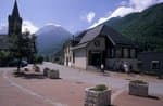
The Désert-en-Valjouffrey
No sand or barren lands, the name of Desert comes from the word "essarter" which means to clear the land of forest in order to produce a clearing. Forest clearing was necessary for the implementation and the development of agriculture in the mountains... Nowadays, the Desert is one of the only hamlets at altitude which is inhabited all year round in spite of the harsh mountain climate.
- History
Paravalanche
In 1961 and 1962 big avalanches descended as far as the riverbed of the Bonne, threatening the houses in the hamlet at Désert en Vajouffrey. In 1982 major works enabled the construction of a paravalanche in order to increase the safety of the hamlet and the prairies, by diverting possible threats coming from the Côte-belle valley.
 Geology and geography
New path
The last section of the path allows access to the mountain pass has required numerous days of maintenance since its creation. In fact the unstable character of the soil associated with the steepness of the slope have made it necessary for the rangers to create wooden benches to contain the weight of the earth.. In Autumn 2012, it was decided to create a new section of the path by using part of a sheep track further East in the direction of the Marmes mountain pass. The work was carried out by a team creating 50 m per day during 26 days with pick-axes and courage. In total, it is a section measuring 1300 m which has been created, which makes the path less steep and much more stable.
 Fauna
FaunaViviparous Lizard
The viviparous lizard can be distinguished from the wall lizard by its rounded muzzle. It is capable of living at an altitude of 2500m and you will most often see them in the meadows. It likes to warm itself in the sun, resting on the grass or the dry moss to hunt grasshoppers, crickets or spiders. During the winter, it buries under the ground where in a lethargic state it can survive negative temperatures. The viviparous lizard is named like this because the females keep their eggs in their abdomen up until they hatch. So the young are completely formed when they are born, it is an adaptation to the cold environment.
 Flora
FloraEdelweiss
In Latin léontopodium signifies the foot of the lion which is the general shape of the edelweiss. By looking at it closely, you realize that it is not one flower but a group of 5 to 10 flowers grouped in a flower head. The edelweiss is in the astéracées family like dandelions. It is a white plant, milky and perennial growing in rocky alpine meadows at subalpine level up to 2900 m. It often mixes with the Alpine Aster. The emblem of numerous guides, it symbolizes the high mountains and represents strength in the language of flowers...
 Panorama
Landscape of the cirque de Valsenestre
From the mountain pass, climb the little summit above to better see the landscape which shows the cirque de Valsenestre : on the left is the Signal du Lauvitel (2901m) and the Clapier du Perron (3169m), the mountain pass at Muzelle (2613m) where the GR54 is. At this level you can really see a geological fault separating the Grandes Rousses which are granite from the Muzelle block in gneiss. On the right, the principal summits are the Roche de la Muzelle (3465 m), and the pointe Swan (3294m). Le col de Côte-Belle separates the Pic de Valsenestre (2752m) on the left from the l’Aiguille des Marmes (3046 m) on the right.
Description
Park your car at the entrance to the Desert. Cross the village up until the torrent de la Laisse without passing it and continue North in the direction of the Côte Belle mountain pass. The path follows the carved out channel of the torrent and passes close to the paravalanche. . The itinerary runs through the heart of the Ecrins National Park. It goes down next into à quite narrow gorge. The track continues its accent with large bends through ancient hay fields and comes out in the Côte Belle mountain pass. The view is of the Arcanier massif, the pic du Clapier du Peyron, la Roche de la Muzelle and the other summits and glaciers of the cirque de Valsenestre. The descente follows the same path.
- Departure : Le-Désert-en-Valjouffrey
- Towns crossed : Valjouffrey
Forecast
Altimetric profile
Sensitive areas
Alpine ibex
- Impacted practices:
- Aerial, , Land, Vertical
- Sensitivity periods:
- JunJulAugSep
- Contact:
- Parc National des Écrins
Julien Charron
julien.charron@ecrins-parcnational.fr
Recommandations
Take water with you to the Désert since there are no sources of drinking water along this itinerary. Protect yourself from the sun because the valley is exposed to the South...

Information desks
Maison du Parc du Valbonnais
Place du Docteur Eyraud, 38740 Entraigues
Reception, information, temporary exhibition room, reading room and video-projection on demand. Shop: products and works of the Park. Free admission. All animations of the Park are free unless otherwise stated.
Access and parking
From Entraigues take the direction to Valjouffrey (D117). Continue along the valley to the hamlet of Désert en Valjouffrey.
More information
Source

Report a problem or an error
If you have found an error on this page or if you have noticed any problems during your hike, please report them to us here: