La boucle de Tirière
In the summer, an early start means you will be able to witness the wakening of daytime animals. Birdsong, that is quite reserved at dawn, becomes more intense as the sun rises. Sometimes, as you climb up, a misty haze makes the larch trees look ghost-like. The outstanding landscapes from the plateau onwards, change from one moment to the next. The Sirac and the Rouies come out of the shade and become red, pink or even golden, depending on the light in the sky.
8 points of interest
 Pastoralism
 History
The Chauvetane mine
In the 19th century, the Valgaudemar area experienced a mining rush. Several explorations uncovered a few veins that were the start of mining operations for lead sulphide or argentiferous galena in the Navette valley, at Le Roux or even in La Chauvetane. An English mining company called the "Valgaudemar Mining Company Limited, associated with a Saint-Firmin notary, was founded in 1861. The work of the peasant-miners in the valley, on the steep rock face of the Chauvetane, was essentially to dig out tunnels leading to the veins where the ore was extracted and sent down to the Condamine. There, women would load it onto donkeys and take it down to the present day Xavier Blanc mountain refuge, where it was processed. The operation was not viable however, and the activity finally ceased in 1923. Panorama
Landscapes and summits
The panorama evolves whilst crossing the Tirière plateau. To start with, walkers have a view of the Gioberney cirque and the surrounding summits, including Les Rouies and its glacier. Further on, the Sirac dominates and the eye is drawn to the Surette valley with a view of the Valgaudemar valley. Opposite, on the other side of the Surette valley, the Morge peak looks like it is poised at the junction of the valleys as a lookout tower. Fauna
FaunaHigh altitude birds
The Tirlière plateau is an ideal spot for observing avifauna of the open altitude environment. The song of larks, water pipits and black redstarts will accompany you on this walk. At a bend, you might see a magnificent common rock thrush or a kestrel in the "Holy Spirit" hovering position that makes it easy to identify. Tirière is also a reference site for tracking the chamois population in the Ecrins National Park. Flora
FloraPlant variety
This route goes through a large variety of plant formations such as eutrophic tall herbs, larch forest, rhododendron or blueberry moors, pastures, scree and rocky areas. A few flowers catch the eye such as alpine anemones, asphodels, Turk's cap lilies or the beautiful orange lily. Amidst this multitude of species, you will need to be very careful if you wish to find the rare dragonhead flower. However, it will be easier to find a nigritella, which is a small orchid with a strong smell of vanilla, or an astragalus, which produces impressive fruits in the form of packed pods.- History
The Minister's footpath
A strange name for a footpath... Two explanations are given. The first, simply suggests that a minister inaugurated, or at least used, the footpath. The second, which is more likely, explains that donkeys were also known as ministers. Indeed, these animals were priceless to peasants of the time and they were pampered and treated accordingly. This path, which is mostly flat would have been well suited for them, and it would seem logical that it was given this name.  Hut
HutChâlet-hôtel in Gioberney
The construction of the chalet-hôtel at Gioberney started during the Second World War as part of a youth project. It enabled some young people the possibility of escaping obligatory work service in Germany (STO). The stones for the building were taken on the spot, cut and put together using cement mortar. At that time the road to Gioberney did not yet exist, and would only be built in 1963. You had to go up on foot, for « tired intellectuals », it was possible to be helped by a mule in order to reach the refuge. There was not much frequentation until the construction of the road...
- Fauna
Northern Bat
The Northern Bat is a boreal bat, a glacial relict in the Alpine arc. Adapted to the cold, it resists temperatures close to -7°C for short periods of time. The Northern Bat is a discreet species that lives in boreal forests scattered with humid areas. It sometimes hunts near to public lighting, one of the only places where it is easy to observe it. The capture of females at this site has enabled us to believe in the presence of a colony at Gioberney. It would be the first known reproducing colonies in France.
Description
From the Gioberney car park, follow the signs to "Tirière" on the cirque terrace. They lead to a footbridge over the stream. Follow the footpath that comes close to the Gioberney mountain hut (please do not disturb the shepherd). Between this hut and a small larch forest, a sign indicates that you should turn right to cross a second bridge over the stream. From there, another sign indicates "Tirière" to the left. Follow the path that heads through an area of large-leaved plants, before meandering through the larch trees and crossing over moors and pastures. At approximately 2000 m in altitude, follow the arrow that leads you to continue up further (follow the most obvious footpath and not the old mining path, which is not maintained and is high and dangerous). You will come to the "Tirière plateau", where the footpath, leading to the ruins of the Tirière mountain hut, is almost flat. The downward route quickly arrives at the edge of the plateau: the first bends are a little steep, but it then gets easier. Where the route meets another footpath, leading to the Pis mountain hut, turn right and follow the large bends that head down. After crossing a small glacial cross-cliff, take the Minister's footpath then turn right to get to the Minister's car park by means of a flat path. Cross the bridge over the stream that leads to the car park. Take the path indicated by an arrow that leads to the Bride's veil (voile de la mariée) waterfall. Follow the paved road for roughly thirty metres, after crossing the stream take the footpath to the left as shown by an arrow.
- Departure : Gioberney
- Towns crossed : La Chapelle-en-Valgaudemar
Forecast
Altimetric profile
Recommandations
Before you reach the Tirière plateau be sure not to take the old mining path (high and dangerous), but follow the route indicated. After the Tirière mountain hut, be careful on the first part of the descent, particularly in wet conditions. At the Gioberney mountain hut, please respect the shepherd's peace and quiet.
 In mountain pastures, protection dogs are there to protect the herds from predators (wolves, etc.).
When I hike I adapt my behavior by going around the herd and pausing for the dog to identify me.
Find out more about the actions to adopt with the article "Protection dogs: a context and actions to adopt".
Tell us about your meeting by answering this survey.

Information desks
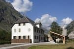
Valgaudemar Park house
Ancien Asile Saint-Paul, 05800 La Chapelle-en-Valgaudemar
Information, documentation and a reception area with permanent and temporary exhibitions. La Maison du Parc is labeled "Tourism and Disability". Free admission. All animations of the Park are free unless otherwise stated.
Transport
Shuttle from Saint Firmin during the summer (it is necessary to reserve 36 hours in advance at voyageurs05 or by calling 04 92 502 505). Connect with buses coming from Gap or Grenoble.
Access and parking
From the N85 at Saint Firmin, take the D58 and the D958a as far as La Chapelle en Valgaudemar. Then take the D480t as far as the Gioberney car park.
Parking :
More information
Source

Report a problem or an error
If you have found an error on this page or if you have noticed any problems during your hike, please report them to us here: